App Store Screenshots (18)


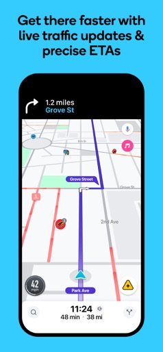
Design Analysis
Visual Design
Style: Material Design
Key Features Shown
- •Turn-by-turn navigation
- •Satellite view
- •GPS metadata camera
- •Nearby POI search
- •3D Famous landmarks
App Insights
Target: Budget-conscious Android users in emerging markets (Bangladesh, Brazil, Algeria) looking for all-in-one utility tools beyond standard Google Maps.
- •Aggressive interstitial ads
- •Banner ads
- •In-app purchases for premium/ad-free
- •Subscription (reported $20/month after trial)
ASO Keywords:
About GPS Navigation: Live Maps View
Navigate with confidence using GPS Live Earth Navigation, the all-in-one GPS and map app for driving, exploring, and discovering the world. Whether you’re planning a cross-country road trip, commuting in heavy traffic, or searching for the perfect parking spot, this GPS satellite map provides precise routing, voice navigation, and powerful tools to make every trip effortless and enjoyable. Key Features & Benefits - Precision Live GPS Navigation & Nearby Places - Real-time GPS navigation with turn-by-turn directions for driving, walking, cycling, or off-road adventures. - Voice-guided directions and alerts to keep your eyes safely on the road. - Instantly locate your position with the Live Location Finder (latitude & longitude + address) for easy sharing. - Discover nearby restaurants, landmarks, shops, and attractions—perfect for city travel, daily errands, or road trips. Customizable Map Styles & Views Multiple map styles: Default, Satellite, Light Mode, Dark Mode, Terrain, Traffic. Switch map modes: Normal, Satellite View, Terrain, or Traffic to suit your travel or exploration needs. Advanced Navigation Tools - Currency converter for travellers. - QR Code Scanner for quick scanning & sharing. - Digital speedometer & compass for orientation and safety. - Parking Finder & Weather Updates for stress-free navigation. - Live Traffic Map & Satellite Map layers to avoid traffic jams and plan efficient routes. - Trip Planner to chart routes, estimate travel times, and organize journeys. - Altitude & Area Measurement for hiking, exploration, or property mapping. - World Clock & Country Information help to check times and country details(Calling Code, Language, Currency) while travelling. GPS Map Camera for Memories - Capture photos with GPS overlay, including coordinates, address, date/time, and map style. - Use flash, timer, and custom map styles (Normal / Satellite Map/ Terrain / Hybrid) for memorable travel pictures. Privacy, Permissions & Ease of Use GPS Earth Map Radar Navigation only requests essential permissions for accurate GPS navigation, map display, and location services. Your privacy is respected, and the app is designed to work smoothly without unnecessary data access. Feedback & Support We value your feedback! Share suggestions or report issues to help us improve GPS Earth Map Radar Navigation. Contact our support team at support@cloudparkstudio.com
Create screenshots like GPS Navigation: Live Maps View
Use FlyerBanana's free editor to create professional App Store screenshots inspired by GPS Navigation: Live Maps View's design. 100+ templates, device frames, and one-click export.