
App Store Screenshots (16)


Design Analysis
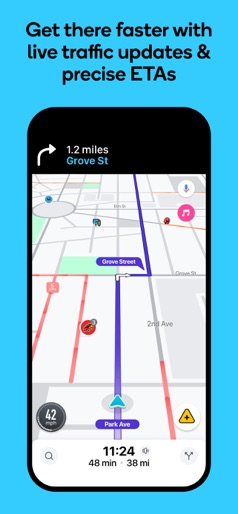
Visual Design
Style: Material Design
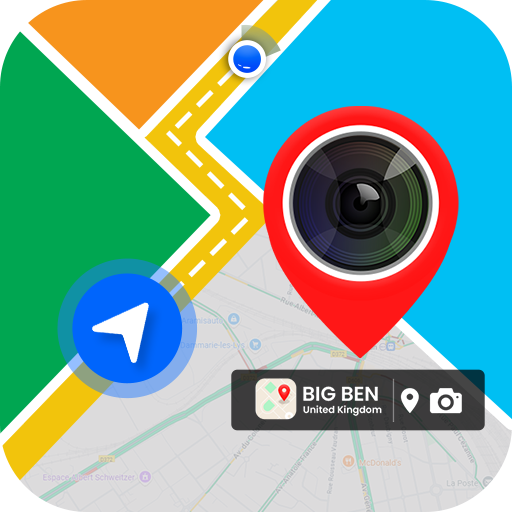
Key Features Shown
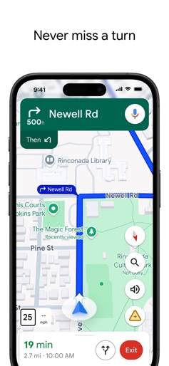
- •Turn-by-turn navigation
- •Satellite view exploration
- •Geotagged photo timestamping
- •Fuel consumption calculator
- •Route saving and management
App Insights
Target: Field professionals (real estate, construction), travelers, and budget-conscious drivers in emerging markets looking for an all-in-one utility tool.
- •Ad-supported (Interstitials, Banners)
- •In-App Purchases (Ad Removal/Premium Features)
ASO Keywords:
About GPS Map Camera & Navigation
GPS Map Timestamp Camera, & GPS Navigation App GPS Map Camera & Navigation app lets you capture geotagged photos with the GPS camera and timestamp camera, add map locations using the map camera, and follow routes with built-in GPS navigation tools. GPS Map Camera is designed for anyone who needs to add locations on photos, add timestamps, explore areas, or find directions. Capture Photos with Location and Timestamp GPS Camera & Timestamp Camera: Take photos with GPS details like latitude, longitude, altitude, direction, and a visible timestamp. Perfect for travel, work, or daily use. Map Camera: Add map locations on your photos to record where and when each moment happened. Geotagged Photos and Selfies: Save memories with GPS tags and timestamps using the GPS map camera and timestamp camera. Location Stamps: Add your current location and timestamp directly to images using the GPS map camera. Use GPS Map & Navigation for Directions GPS Navigation: Get step-by-step directions with live traffic updates. Route Planning: Find short with traffic updates for your trip. My Location: Share your current GPS location with contacts when needed. Save Parking Location: Save your car’s location and use GPS map navigation to return later. Extra Tools in the GPS Camera App Fuel Calculator: Check fuel costs based on route distance and fuel price. GPS Compass: Use a digital compass to check directions on the go. Speedometer: See your current speed while traveling. Nearby Places: Find restaurants, hospitals, hotels, ATMs, and more. Location Finder: Locate stations, services, and other important places using the GPS map camera. Who Can Use This App Travelers and Bloggers: Use the map camera and timestamp camera to take geotagged and timestamped photos. Real Estate Agents: Add location info and timestamps to property photos using the GPS camera. Event Planners: Save photo records with the map camera and timestamp camera. Hikers and Explorers: Navigate trails and capture images with location and timestamp data. Daily Drivers: Plan routes, track speed, save parking spots, and document trips with timestamps using GPS map navigation. Download GPS Map Camera & Navigation App Now The app works as a GPS map timestamp camera and GPS navigation tool to help you capture photos with locations, times, and travel routes.
Create screenshots like GPS Map Camera & Navigation
Use FlyerBanana's free editor to create professional App Store screenshots inspired by GPS Map Camera & Navigation's design. 100+ templates, device frames, and one-click export.
More Maps & Navigation Apps
View all

United Airlines
Maps & Navigation
Google Maps
Maps & Navigation


Southwest Airlines: Travel App
Maps & Navigation


The Weather Channel - Radar
Maps & Navigation

Expedia: Hotels, Flights, Cars
Maps & Navigation

Waze Navigation & Live Traffic
Maps & Navigation